
Avisos y Recomendaciones
APERTURA TEMPORADA PESCA 2026
Se comunica a los socios del COTO PRIVADO DE PESCA DE LAS BARDENAS REALES DE NAVARRA EBR-0095-P la apertura de la Temporada 2026.
Cierre Accesos Zona ZEPA 2026
La Comunidad de Bardenas Reales de Navarra informa de la limitación temporal de acceso a determinados parajes incluidos dentro de la Zona de Especial Protección para las Aves (ZEPA) «El Plano – Blanca Alta». Esta medida, adoptada mediante Resolución de Presidencia 2026-0055 de 26 de enero de 2026, tiene como objetivo principal garantizar la tranquilidad durante la época crítica de reproducción de las aves rapaces rupícolas protegidas.
CIERRE SENDERO ACCESO AL CABEZO DE CORTINILLAS
29/01/2021: Cierre del sendero de acceso al Cabezo de Cortinillas por riesgo de desprendimientos. Por seguridad, respete las indicaciones.
CÁMARAS EN DIRECTO DE NIDOS EN EL PRIMILLAR
Ya está activo el acceso a las cámaras para poder observar en directo nidos de cernícalo primilla, cernícalo vulgar, mochuelo europeo y lechuza.
SE ACONSEJA EXTREMAR LAS PRECAUCIONES SI SE TRANSITA POR EL PARQUE EN DÍAS DE LLUVIA.
Desde el órgano gestor del Parque Natural y Reserva de la Biosfera de Bardenas Reales de Navarra, se recomienda extremar la precaución si se transita en vehículos o cualquier otro medio dentro del espacio protegido, desaconsejándose la entrada si las lluvias son persistentes o han afectado al estado de pistas y caminos.
L´organe de gestion du Parc Naturelle et la Reserve de la Biosphère de Bardenas de Navarre, nous recommandons la plus grande prudence si on transit avec de véhicules ou d’autres moyens dans la zone protégée, entrée pas recommandé si les pluies sont persistantes ou ont affecté l’état de pistes et des routes.
From the managing personal of the Natural Park and Biosphere Reserve of Bardenas of Navarra, we recommend to extreme caution when driving vehicles or going inside the protected area, also we do not recommend to entry if the rain is persistent or has affected the state of tracks and roads.
Concurso de Fotografía «MEMORIAL JULIÁN ISLA» 2025-2026
Bases de participación para el VII Concurso de Fotografía "MEMORIAL JULIÁN ISLA"
Normativa de Caza
Normativa de Caza para la temporada Cinegética 2025-2026
Cátedra Bardenas
La misión fundamental de la cátedra es fomentar, en el ámbito del parque natural y reserva de la biosfera de las Bardenas Reales de Navarra, el desarrollo de acciones para generar conocimiento en áreas de Ingeniería y Tecnología, Ciencias Básicas y de la Salud, Ciencias Económicas y Jurídicas y Ciencias Humanas y Sociales.
RODAJES: Normativa y Solicitud
Filmaciones y reportajes fotográficos, con fines comerciales o divulgativos, en el Parque Natural y Reserva de la Biosfera de Bardenas Reales de Navarra.
Saber MásConcurso 'Memorial Julián Isla'
Bases de participación y Ficha de Inscripción Concurso de Fotografía y Cortometrajes 'Bardenas Reales - Memorial Julián Isla'
Saber MásSede Electrónica
Plataforma de acceso a los servicios electrónicos que la Comunidad de Bardenas pone a su disposición; trámites las 24 horas de los 365 días del año.
VerPlan de Ordenación de los Recursos Naturales
Herramienta de planificación y gestión territorial - Normativa de Ordenación de Bardenas
Saber MásÚltimas Noticias
-
 10/06/2026
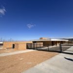
La Comunidad de Bardenas Reales visita los nuevos centros turísticos y diversas infraestructuras ganaderas estratégicas
La Comisión Permanente de la Comunidad de Bardenas Reales, junto con representantes de varias entidades congozantes, ha realizado una visita […]
-
 27/05/2026
Mujeres, Leyendas de Deporte Navarro
Reconociendo trayectorias que han abierto camino. El viernes, 22 de mayo, se presento en la sede de la Comunidad de […]
-
 21/05/2026
Bardenas Reales celebra el Día Europeo de la Red Natura 2000 destacando el valor de su patrimonio natural
La Comunidad de Bardenas Reales se suma este 21 de mayo a la celebración del Día Europeo de la Red […]
-
 09/05/2026
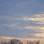
La Comunidad de Bardenas Reales se suma al Día Mundial de las Aves Migratorias 2026
Bardenas Reales, 9 de mayo de 2026.- La Comunidad de Bardenas Reales se suma hoy a la celebración del Día Mundial de […]